
FAQs
- New controlled pedestrian and cycle crossings on all approaches to the junction, allowing people to cross in one movement without having to wait on a central island.
- A new dedicated cycle crossing on Station Road (south west). This would provide a safer crossing for cyclists travelling to and from Harrow and would connect with the existing two-way cycle track.
- Shared use footways at the corners of the junction. These would allow cyclists to pass through the junction without mixing with traffic and would particularly benefit less experienced cyclists.
- Wider footways at crossing points. These would shorten the distance pedestrians and cyclists need to cross and help reduce vehicle speeds.
- Left turn restriction from Pinner Road (north west) to Station Road (north east). This would help allow the new straight-across controlled pedestrian crossings to be introduced. Relatively few vehicles currently make this turn and drivers would be able to use Canterbury Road as an alternative route.
- Right turn restriction from Station Road (north east) to Pinner Road (north west). This is proposed to address safety concerns with right-turning vehicles and would also allow the new straight-across controlled pedestrian crossings to be introduced.
- We are also considering whether other improvements could be made around the junction. These could include trees and planting, measures to help reduce flooding such as rain gardens, seating, litter bins, improved lighting or public art.
Why are changes being proposed at the Pinner Road and Station Road junction?
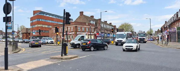
The Pinner Road and Station Road junction is busy and can be difficult to cross, particularly for people walking and cycling. There are currently no controlled pedestrian crossings on three sides of the junction and visibility can be difficult for drivers making some turns.
There have been a number of collisions at the junction, including collisions involving pedestrians and a fatal collision involving a cyclist.
The junction is used by many people, including school children, older people and people with disabilities. The proposed changes aim to make it safer and easier for everyone to get around.
Transport for London (TfL) and the London Borough of Harrow have identified the junction as a priority for road safety improvements.
How is the scheme being funded?
The junction has been identified as a priority for improvements in Harrow. Following development and assessment of the scheme, Transport for London (TfL) has awarded funding to the London Borough of Harrow specifically for the proposed improvements to the Pinner Road and Station Road junction.
What changes are being proposed?
The proposed changes include:
What can be included will depend on consultation feedback, available funding and what is physically possible at the junction.
Has any engagement been completed to develop the proposals?
Yes. In July 2024, the Council held an initial workshop with local interest groups in North Harrow to identify key issues at the junction and gather ideas for potential improvements. This feedback was used to develop a range of design options, which were subsequently assessed using traffic modelling.
A second workshop was held in March 2025 to present and discuss the preferred scheme with local interest groups. Feedback received during this engagement was used to further refine the design.
Transport for London has also been closely involved throughout the design process, helping to develop and refine both the proposed layout and traffic signal operation.
Why are you proposing to ban some turns?
The two proposed turning restrictions would help reduce conflicts between different road users, improve safety, allow the new pedestrian and cycle crossings to be introduced and allow the junction to operate effectively for traffic.
Left turn restriction from Pinner Road (north west) to Station Road (north east): Relatively few vehicles currently make this turn. Drivers would instead be able to use Canterbury Road.
Right turn restriction from Station Road (north east) to Pinner Road (north west): This is proposed to address safety concerns related to the lack of visibility for right-turning vehicles. Traffic modelling also found that retaining this turn alongside the other proposed changes would result in greater congestion and longer journey times through the junction.
How will drivers access roads affected by the banned turns?
Drivers will still be able to access all roads in the area, but some journeys may need to use an alternative route.
Signs and the road layout would guide drivers along alternative routes. Access to homes, businesses and other local destinations would be maintained.
What traffic modelling has been carried out and what does it show?
Different options for the layout and operation of the junction have been developed and assessed using traffic modelling. These included different crossing arrangements, retaining existing traffic movements and different traffic signal arrangements.
The modelling shows that there are likely to be some longer queues and increases in journey times, although the overall impact on nearby roads and junctions is expected to be very low.
On most approaches, journey times are expected to increase by less than 30 seconds during peak hours. Traffic turning right from Station Road (south west) to Pinner Road (south east) could experience an increase of around 60 seconds at peak times.
Traffic signals in London are managed by Transport for London (TfL). TfL has reviewed and approved the traffic modelling for the proposed scheme, including the expected small impact on traffic and bus journey times.
Will the turning restrictions increase traffic on surrounding roads?
Fewer than 20 vehicles currently make the left turn from Pinner Road (north west) to Station Road (north east) during the morning and evening peak hours. These vehicles are expected to use Canterbury Road instead.
Around 75 to 80 vehicles currently turn right from Station Road (north east) to Pinner Road (north west) during the busiest hour. Some are expected to use a different route, while others may use alternative roads nearby.
The potential impact on the wider road network has been considered using Transport for London's strategic traffic model. This indicates that the overall impact on nearby roads and junctions is expected to be very low.
Drivers choosing an alternative route could use roads including Southfield Park, Northumberland Road, Manor Way and Priory Way, although it is difficult to predict exactly which routes individual drivers may choose.
These roads are already covered by traffic calming measures introduced by the London Borough of Harrow as part of separate road safety schemes. These include the Manor Way Area 20mph Zone and the Northumberland Road Area 20mph Zone, which feature speed humps designed to help reduce speed and improve road safety.
Will the changes cause more congestion or longer journey times through the junction?
Traffic modelling shows that there are likely to be some longer queues and minor increases in journey times.
On most approaches, journey times are expected to increase by less than 30 seconds during peak hours. Traffic turning right from Station Road (south west) to Pinner Road (south east) could experience an increase of around 60 seconds at peak times compared with the current situation.
Will traffic be monitored if the changes go ahead?
Yes. If the scheme goes ahead, the London Borough of Harrow and Transport for London will monitor how the junction is operating.
Changes can be made to elements such as traffic signal timings if monitoring shows these are needed.
Will the banned turns be monitored and enforced?
Yes. There is existing CCTV at the junction, which can be used to monitor and enforce the turning restrictions if the scheme goes ahead.
The purpose of the proposed banned turning movements is to improve road safety and manage traffic movements, rather than to generate income. Any revenue received through enforcement is paid into a ring-fenced account and, by law, any surplus must be reinvested in local transport, highway and environmental improvements.
What improvements are proposed for pedestrians?
There are currently no controlled pedestrian crossings on three sides of the junction. The existing staggered crossing on Pinner Road (north west) also means people have to wait on the central island before completing their crossing.
The proposals would introduce new straight-across controlled pedestrian and cycle crossings on each approach to the junction. This would allow people to cross in one movement rather than having to wait on a central island.
The traffic signals would include a dedicated stage for pedestrians to cross so they do not need to risk crossing the road when traffic is moving. Wider footways at crossing points would also shorten the distance people need to cross.
The changes are intended to make the junction safer and easier to use, including for school children, older people and people with disabilities or mobility needs. The improvements would also help make North Harrow a more attractive place to visit.
How will the proposals improve safety for cyclists?
The proposals aim to reduce points where cyclists and motor traffic come into conflict.
They include a dedicated cycle crossing on Station Road (south west), straight-across cycle crossings and shared use footways at the corners of the junction. These would allow cyclists to pass through the junction without mixing with traffic.
The designs have been reviewed and revised following feedback from Harrow Cycle Hub and Transport for London (TfL).
How have you considered people with disabilities and mobility needs?
Accessibility has been an important part of developing the proposals.
The proposed straight-across controlled pedestrian crossings, shorter crossing distances and dedicated pedestrian stage in the traffic signals are intended to make the junction easier and safer to use for people with a range of mobility, visual and accessibility needs.
If the proposals go ahead, accessibility requirements will continue to be considered as part of the detailed design.
What is a shared use footway?
A shared use footway is a section of pavement that can be used by both people walking and cycling.
Under the proposals, there would be short sections of shared use footway at the corners of the junction. These would allow cyclists to leave the road, use the shared area to reach the new cycle crossings and then continue their journey, rather than having to travel through the junction with other traffic.
Will buses be affected?
Buses would continue to use the same routes through the junction.
The changes to the traffic signals needed for the new pedestrian crossings mean there are likely to be some minor increases in bus journey times, typically less than 30 seconds.
The scheme has been designed to minimise the impact on buses while improving safety and providing better pedestrian and cycle facilities. The new controlled pedestrian crossings would improve safety for bus passengers walking to and from bus stops in the area.
Will access to local homes and businesses be affected?
Access to homes, businesses and community facilities would be maintained. Some drivers may need to use alternative routes because of the proposed turning restrictions, but all properties would remain accessible by road.
Will parking or loading be affected?
The current proposals focus on changes to the layout and operation of the junction, and it is not currently intended to change parking or loading arrangements.
If any changes to parking or loading are required as the detailed design develops, we will provide further information about these.
Will emergency services still be able to access the area?
Yes. The scheme will be designed to maintain access for emergency service vehicles.
Emergency access requirements will be considered as part of the detailed design to make sure police, fire and ambulance services can continue to access the area.
What improvements are proposed for Canterbury Road, the section between Pinner Road and Station Road?
The proposals for this section of Canterbury Road include replacing the existing painted contra-flow cycle lane with a stepped cycle track. This would provide greater separation from motor traffic, improving safety and comfort for cyclists while creating a more accessible route for people of all ages and abilities.
The proposed improvements would complement the planned Pinner Road and Station Road junction scheme, helping to provide a safer and more coherent cycling connection through the area.
How do these proposals link with the North Harrow section of the Harrow to Pinner Cycleway Improvement Scheme?
The Pinner Road and Station Road junction improvements form part of wider transport improvements in North Harrow.
The proposed junction improvements would connect with the Harrow to Pinner cycle route improvements being delivered in the area, helping to provide a safer and more continuous route for cycling. The junction proposals have been developed alongside the Harrow to Pinner improvements to make sure the two schemes work together.
What is happening with the proposals for the George V Avenue/Pinner Road/Headstone Lane junction and Imperial Drive/The Ridgeway junction?
Both schemes were included in the London Borough of Harrow's Local Implementation Plan funding submission to Transport for London (TfL).
At this stage, full funding has only been secured for the Pinner Road and Station Road junction improvements.
The other two schemes have progressed to the feasibility stage and we will continue to work with TfL to seek funding for their further development. Until further funding is confirmed, we cannot provide a timetable for these schemes.
What is happening with the proposals for the Headstone Lane/ Harrow View /Headstone Gardens Junction, commonly known as Goodwill to All junction[H?
The Goodwill to All junction improvement proposals are currently on hold while the Pinner Road and Station Road junction scheme is prioritised.
It would not be practical to carry out both schemes at the same time because of the disruption this could cause to traffic in the area.
The Pinner Road and Station Road scheme has therefore been prioritised. The programme for the Goodwill to All junction will be reviewed once this work has progressed.
How can I have my say?
We want to hear what you think about the proposed changes. Complete the survey on this page by 2 November 2026.
We are also holding two drop-in sessions in North Harrow where you can find out more about the proposals, ask questions and share your views with the project team. See the Key Dates section for further details.
What happens after the consultation closes?
After the consultation closes, we will consider your feedback alongside the technical information before a final decision is made.
The results will be shared with local ward councillors and reviewed by the Highways Decision Board, which includes the Portfolio Holder for Finance and Highways, the Leader, Deputy Leader and senior officers. The Board will decide whether the scheme should progress to the next stage. The proposals may be revised to reflect comments and feedback received during the consultation.
We will publish the consultation results on MyHarrow Talk and explain the final decision, including any changes made to the proposals following feedback.
If approved, construction is expected to start in spring/summer 2027.